
The San Andreas Fault is so famous it’s the star of a recent movie. After all, that fault line has caused recent sizable earthquakes like Loma Prieta in 1989 and Northridge in 1994, and the world-famous San Francisco earthquake in 1906. But the San Andreas fault’s nearest neighbor, the far more dangerous Cascadia subduction zone has remained obscure, ignored, and denied—despite dozens of state task-force reports from Oregon and Washington, as well as news media on the subject, including a BBC documentary.
In fact, it wasn’t until this month, when The New Yorker magazine published “The Really Big One,” by Katherine Schultz, whose article lays out the scenario of devastation expected to be brought about by the Cascadia mega-earthquake and tsunami within the Pacific Northwest, that Pacific Northwesterners, Americans, and indeed, the world, began talking about Cascadia. Not only is the next Cascadia earthquake overdue, but the buildings and infrastructures of the cities it will hit along the coastline—including Portland and Seattle—are nowhere near ready for it. And meanwhile, seismic activity is happening every 15 minutes somewhere along the East Coast, according to the U.S. Geological Survey’s real-time earthquake map.

What is the Cascadia subduction zone? Also known as “the mega-thrust zone,” the Cascadia subduction zone is a 700-mile fault line below the floor of the Pacific Ocean, stretching from Cape Mendocino, Calif., to Vancouver Island, Canada. The fault line parallels the Cascade Range of volcanic mountains that run about 100 miles inland from the shoreline, starting in Northern California and ending in British Columbia, Canada. In the Cascadia subduction zone, one tectonic plate—the 90,000-sq.-mile Juan de Fuca—is sliding underneath North America, and the volcanic mountains of the Cascade Range mark the line where the “Juan de Fuca plate is heating up and melting everything above it,” reports The New Yorker. This is causing the stuck edge of North America—namely, the Pacific Northwest region—to bulge at a rate of three to four millimeters annually, and to compress eastward at 30 millimeters to 40 millimeters as well.
What kind of damage could the Cascadia mega-earthquake and tsunami produce? The southern end of the Cascadia subduction zone is stuck. If it suddenly slips, the resulting earthquake’s magnitude will be between 8.0 and 8.6. But if the plates give way along their entire length, the magnitude will be between 8.7 and 9.2. That’s, respectively, “the big one” and “the very big one,” writes Schultz.
If “the very big one” hits, the Pacific Northwest region will drop by as much as 6 ft. and then rebound 30 ft. to 100 ft. westward. A colossal amount of the ocean will be displaced, sending waves rushing westward, toward Japan and eastward, in what The New Yorker article describes as “a 700-mile liquid wall that will reach the Northwest coast, on average, 15 minutes after the earthquake begins.”
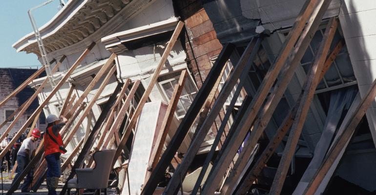
Where will the earthquake’s greatest impact be? “Everything west of Interstate 5 will be toast,” a Federal Emergency Management Agency (FEMA) official, working in Region X (Oregon, Washington, Idaho and Alaska), told The New Yorker. However, Chris Goldfinger, the director of the Activa Tectonics and Seafloor Mapping Laboratory at Oregon State University (OSU) in Portland—who, incidentally considers The New Yorker article essentially accurate—recently told Oregonlive.com that although he expects the worst-case scenario to be dire, FEMA’s “toast” comment is an overstatement. But, on the other hand, after surviving the 2011 earthquake in Japan, one of the world’s leading countries when it comes to earthquake preparedness, Goldfinger also told The New Yorker, “If that was Portland, let’s just say I would rather not be here.” Test models of tsunamis hitting the Oregon coast, undertaken in the OSU laboratory, bear out his view.
On the West Coast, Interstate 5 cuts through several Pacific Northwest cities, including Portland, Eugene, Salem and Medford in Oregon and Olympia, Tacoma and Seattle in Washington. The total population of the region, which covers approximately 140,000 sq. miles, is about 7 million. FEMA is preparing for an earthquake of 8.0 to 9.2 in magnitude; the agency estimates that 13,000 people will be killed and 27,000 people will be injured. FEMA already has plans to provide shelter for 1 million displaced people, plus food and water for another 2.5 million people. And if the event takes place during the summer, when the beaches are full of vacationers, reports The New Yorker, the casualties “could be off by a horrifying margin.”
How likely will the next Cascadia earthquake—whether it’s “big” or “very big”—happen in the next 50 years? It’s easy to do the math. The last Cascadia earthquake and tsunami occurred on January 26, 1700. In the past 10,000 years, geologists have determined, the Pacific Northwest has experienced 41 Cascadia-subduction-zone earthquakes. Divide 10,000 by 41 and you get Cascadia’s recurrence interval: 243 years. It’s now 315 years since the 1700 earthquake. That means the next Cascadia earthquake is overdue.
The odds of “the big one” happening within the next 50 years, reports The New Yorker, are about 1 in 3. The odds of “the very big one” happening within the next 50 years are approximately 1 in 10. Also, in 2010, Oregon State University geologist Chris Goldfinger told the Associated Press, “There is an 80 percent chance the southern end of the fault off southern Oregon and Northern California could break in the next 50 years and produce a Megaquake.”
Are Pacific Northwestern commercial buildings prepared? According to a March 23, 2010 Seattle Post-Intelligencer article by architect Blaine Weber, director of Weber Thompson’s high-rise design studio in Seattle, two seismological researchers at the California Institute of Technology (Caltech), Thomas Heaton and Jin Yang, found that Caltech simulations show that mega-quakes—characterized as such because they last for more than four minutes, reach a magnitude of 9.0 or more and are dominated by low-frequency motions—“would be exacerbated by the geography of the Seattle basin.”
This, notes Weber, could “cause severe damage among older high-rises built before building code changes made as a result of the 1994 Northridge earthquake…particularly steel-framed buildings with outmoded ‘brittle welds.’ [Newer buildings have been constructed to more rigorous structural standards.]”
In addition, reports Weber, “Buildings that are built in accordance with newer building codes are certainly the safest, but older buildings need to be seismically reinforced in order to provide the proper measure of safety.” But, he adds, “There is no such thing as an earthquake-proof building, but our technology is at a place where we truly can prevent the collapse of buildings and the loss of life.”